Die sogenannte "Knopfkarte" als Illustration zu Isidor, De natura rerum, X, 2
- Anna-Dorothea von den Brincken: Fines Terrae. Die Enden der Erde und der vierte Kontinent auf mittelalterlichen Weltkarten. Hannover 1992. S. 52f:
- Wesley M. Stevens: The figure of the earth in Isidore's "De natura rerum". In: ISIS 71 (1980), S. 273f.
- Umzeichnung der Knopkarte in J. Fontaine, Isidore de Seville - traité de la nature, Bordeaux 1960, S. 210bis und Erläuterung derselben ebd., S. 16.
- David Woodward: Medieval Mappaemundi. In: The history of cartography. Vol. 1: Cartography in prehistoric, ancient, and medieval Europe and the Mediterranean. Chicago 1987. S. 320f:
- Umzeichnung der Knopfkarte in "Sancti Isidori Hispalensis Episcopi, opera omnia quae extant." Köln 1617. S. 249.
- Umzeichnung der Knopkarte in MIGNE, PL 83, Sp. 979/80.
Anna-Dorothea von den Brincken: Fines Terrae. Die Enden der Erde und der vierte Kontinent auf mittelalterlichen Weltkarten. Hannover 1992. S. 52f:
"Darüber hinaus sind aber gerade zu De natura rerum noch merkwürdige bildliche Darstellungen der Zonenkarte in Umlauf gewesen als Erläuterung von c. X,230. Dem Erdkreis ist ein kleiner Kreis wie ein Knopf einbeschrieben, umgeben von einem Kranz von fünf Knöpfen. Der innere Kreis zeigt häufig das Brustbild eines Menschen im Profil. Die fünf übrigen einbeschriebenen Kreise vermelden jeweils in ihrer Legende die Beschreibung eines circulus der Zonenkarte. Diese Karte findet sich häufig, sie ist bereits in einer karolingischen Handschrift der Kölner Dombibliothek31 belegt. Hier hat ein Zeichner, der sich die Kugel absolut nicht vorstellen konnte, circulus immer als Kreisfläche auf großer Kreisfläche gedeutet, d.h. diese mit kleinen Kreisen wie mit Knöpfen besteckt, weshalb der Typ "Knopfkarte" genannt werden soll32."
30 Isidor von Sevilla, De natura rerum, ed. FONTAINE S. 209, ABB. dort neben S. 210 als S. 210bis; vgl. dazu STEVENS, Figure S. 268-277.
31 Köln, Dombibl. Ms. 83II, fol. 130v (Abb. 12); beim begleitenden Text handelt es sich fol. 126-145v um einen liber rotarum, de facto um De natura rerum; zum Kartentyp vgl. FONTAINE in der Edition S. 16 und DERS., Isidore de Seville 2, S. 486-489.
32 Vgl. auch MIGNE PL 83, Sp. 979/80 zu De natura rerum X; ferner STEVENS, Figure S. 273-277; Woodward, Reality S. 518 und HARLEY-WOODWARD, Cartography 1, S. 321 sowie SHACKELFORD, Apple S. 80-84.
Wesley M. Stevens: The figure of the earth in Isidore's "De natura rerum". In: ISIS 71 (1980), S. 273f.
"Isidore also explains the five climates of earth in parallel with the five bands of the celestial sphere in De natura rerum X and XII as on the model of our Figures 3 and 4. Chapter X, "De quinque circuli mundi", is plainly based upon the Hellenistic model of a spherical universe (=kosmos =mundus), but it too can be misinterpreted. This is because the language is not at all clear: like Chapters XI and XII it emphasizes the interrelation of all parts of the universe rather than describes th ones in which we are interested; and one of the drawings rearranges the five great zones (circuli) as petals of a flower! However disconcerting it may be as a teaching diagram, that device displays both the northern and the southern temperate zones of the earth as habitable, a touchstone which most modern commentators use as evidence for a concept of sphericity (e.g., Bunbury, Dreyer, Wright, Bagrow)."
Jacques Fontaine: Isidore de Seville. Traité de la nature. Bordeaux 1960. S. 16:
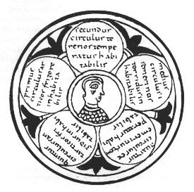
| "III. Roue des cercles du monde (inf. p. 210 bis). - J'ai montré (Culture, t. 2, p. 486) l'absurdité scientifique de ce schéma décoratif, qui ne correspond nullement à la projection des cinq cercles sur une représentation plane de la sphére. La figure a pu être imaginée avant Isidore pour répondre aux besoins d'un enseignement appauvri, et désormais dépourvu de la "sphera" indispensable aux leçons de cosmographie. Cette figure l'analogie des cinq doigts autour de la paume de la main. Elle pourrait donc être indirectement issue d'une Introduction scolaire à la lecture des Phénomènes d'Aratos."
|
David Woodward: Medieval Mappaemundi. In: The history of cartography. Vol. 1: Cartography in prehistoric, ancient, and medieval Europe and the Mediterranean. Chicago 1987. S. 320f:
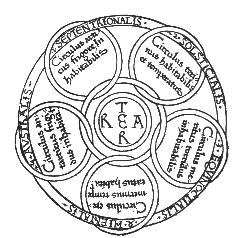
Fig. 18.26 ISIDORE'S VIEW OF THE EARTH'S FIVE ZONES: Isidore applied the Greek concept of zones not to a sphere but to a flat, circular earth, but this probably results from his misunderstanding of the nature of the concept an d does not imply his ignorance of the earth's sphericity.
Diameter of the original: 13.5 cm. After George H.T. Kimpble, Geography in the Middle Ages (London: Methuen, 1938).
|
Other passages in his text have been used to support the idea that Isidore thought the world was flat. In one place, he described the earth as a wheel: "The circle of lands [orbis] is so called from its roundness, which is like that of a wheel, whence a small wheel is called orbiculus".165 In another passage, he seems to have misunderstood the Greek concept of parallel zones from his reading of the Poeticon Astronomicon of Hyginus. He took to literally the statement that the lines separating the zones should be drawn as circles on a globe, and disregarded the possibility that these might look different when drawn on a flat surface. The zones thus appeared as five circles mechanically placed on a disk (fig. 18.26): "In describing the universe the philosophers mention five circles, which the Greeks call parallels, that is, zones, into which the circle of lands is divided. ... Now let us imagine them after the manner of our right hand, so that the thumb may be called the Arctic cicle, uninhabitable because of cold; ... the northern and southern circle, being adjacent to each other, are not inhabited, for the reason, that they are situated far from the sun's course."166 Such an interpretation can hardly be taken as evidence of Isidore's belief in a flat earth, however, when it reflects his inability to grasp the basic geometry of the Greek concept of the climata
165. Isidore Etymologies 14.2.1: "Orbis a rotunditate circuli dictus, quia sicut rota est; unde brevis etiam rotella orbiculus appelatur," in Patrologiae cursus completus, ed. Migne, 82:495 (note 157), author's translation.
166. "In definitione autem mundi circulos aiunt philosophi quinque, quos Graeci parallelois, id est zonas uocant, in quibus diuiditur orbis terrae. ... Sed fingamus eas in modum dexterea nostrae, ut pollex sit circulos arcticos, frigore inhabitabilis; ... At contra septentrionalis et australis circuli sibi coniuncti idcirco non habitantur quia a cursu solis longe positi sunt." Isidore, Traité de la nature, ed. Fontaine, 209-11 (note 84), author's translation. This degeneration of the original climata concept was transmitted to the Muslim world, but with seven circles. See George Sarton, review of Ahmed Zeki Validi Togan, "Biruni's Picture of the World," Memoirs of the Archeological Survey of India 53 [1941] in Isis 34 (1942): 31-32.
|
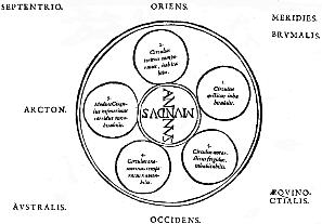
| Sancti Isidori Hispalensis Episcopi, opera omnia quae extant. Köln 1617. S. 249.
|
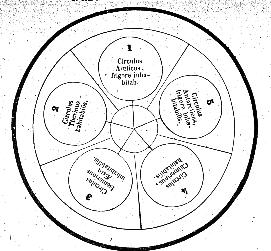 MIGNE, PL 83, Sp. 979/80.


